RSC MINERAL INTELLIGENCE – HOW IT WORKS
WHAT IS RSC-Mineral Intellligence, (RSC-MI)?
RSC-MI is an online interactive map and database repository that displays and stores public reports for mineral exploration and mining projects globally. The majority of the projects included in RSC-MI are undertaken by companies listed on the major global stock exchanges.
Mineral exploration projects are represented by pins on the map. When any pin is clicked a window shows all public reports (Announcements and Technical Reports) available for that project. Along with a download link to each report, the window shows summary information such as the resource statement, best drill intersections, name of the QP/CP, etc. All data displayed on RSC-MI is available in the public domain.
A database of Transaction Reports is also provided which displays and stores global reports published since April 2017 relating to transactions of mineral exploration, resource development, and mining properties, including property acquisitions, company acquisitions and takeovers. Reported transactions are represented by pins on the map. A summary of any transaction report may be viewed by clicking on a pin, and the full report may be downloaded from the summary. Viewing and downloading transaction reports is subject to membership of a relevant RSC-MI subscription plan.
Filters are available for both the Technical Reports and the Transaction Reports to display user-defined subsets of the overall data. Projects can be filtered by various criteria including commodity type, date, project status, stock exchange the company is listed on, reporting code, report type, and transaction size and type. A search tool is available allowing users to search for specific projects, code, competent persons and other relevant fields.
Concept and rationale
RSC-MI was originally designed as a free intelligence tool for the mineral industry.
By monitoring public reports and displaying these spatially, it can be easily visualised, for example, which commodities are being reported on most, which geographic locations are most active, how many maiden resources are reported, and which reporting codes are used. It then becomes easy to generate trend plots, for instance showing trends in reporting activity. As a source of information, RSC-MI, therefore, is a valuable resource for activities such as target acquisition, market research, resource comparison, and for investors, regulators and codes (AusIMM, AIG, ASX, JORC, NI43-101, etc).
RSC-MI will remain free for a limited period.
TYPE OF REPORTS INCLUDED INTO THE DATABASE
RSC-MI includes two categories of reports; Technical Reports concerning mineral exploration and mining projects; and Transaction Reports concerning reported transactions of mineral projects at any stage of development.
Technical reports mostly includes reports that are positioned on the central part of the mining value chain (Figure 1). Projects where substantial exploration work is being completed are of main interest and therefore public reports on the results of early exploration activities such as mapping or soil sampling programmes are not included. Similarly, results for established mines (such as reserve updates based on different cut-off grades) are not included as they have little bearing on the “activity monitor”.
Transaction reports covers transactions of any size/value of mineral projects at all stages of development from exploration through to developed mines on care and maintenance.
We also monitor Environmental Impact Assessment reports (EIAs, Code -unrelated) and reports supporting acquisitions (mostly NI 43-101).
FREQUENCY OF UPDATES
The system is updated daily. However, with the geographical spread of projects and reporting time differences, sometimes there may be a lag of up to a few days.
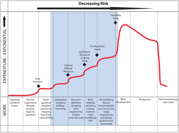 Figure 1 Mining value chain with blue shaded area showing the area and type of reports being covered by RSC-MI.
DOWNLOAD LINKS TO PUBLIC REPORTS
Each project pin on the map includes the download link to the public report. Where possible, we try to include the technical Documentation that goes with the Public Report. For NI43-101 reports, this will be added when it is made available through SEDAR up to 40 days after the Public Report. In the case of JORC, this documentation may not always be available for download.
CODES
Most of the public reporting is based on the NI 43-101 and JORC Codes. These are displayed on the map using either an “N” or “J” within the pin. Other Codes are displayed using an “O”. There may be reports where the Code affiliation may not be provided. This may be a breach of listing rules or otherwise may simply be because the reporting company is private. We treat “public” announcements by private companies as Public Reports.